Search greenbayroute.com:
Green Bay & Western Lines
The East-West Short Route
 [Home]     Information ] Locos ] Rolling Stock ] Photos & Stuff ] Ephemera ] Modeling ] References ] Site Map ]
Swing Bridge

Up ]

Home

Information
Locos
Rolling Stock
Photos & Stuff
Ephemera
Modeling
References
Site Map

What's New?
Guest Book


In the Beginning...
Eastmoor
GB&LP Headquarters
New London Junction
Kewaunee Harbor
Arcadia Washout
Manawa Wreck
Iola & Northern
Ice Jam
St. Paul Coal Docks
Cargill Coal Docks
Hatfield Dam Const.
Omaha Road Crossing
Sturgeon Bay Ship Canal
Wisconsin River Crossing
Waupaca Station
Waupaca Train
Sturgeon Bay Bridge
Stevens Point
Kewaunee
Grand Rapids Bridge
Amherst Junction
Amherst Junction Depot
Big Crowd At Blair
Kewaunee Bridge
Hatfield Bridge
Black Creek Yards
Whitehall
Grand Rapids Bridge
Green Bay Junction
Taylor 1909
Scandinavia Depot
Scandinavia Union Depot
Grain Elevator
Luxemburg
C&NW Bridge Yard
Shiocton Bridge
Station "66"
Amherst Junction
Deer Hunting
Kewaunee Skyline
Manawa Depot
Amherst Junction
Shiocton Street Scene
Trains in Merrillan
Scandinavia Map
Arcadia Excursion
Seymour Station
Sturgeon Bay Depot
Green Bay Station
Merrillan Map
Green Bay Depot
Manawa Station
Turntable Wreck
Arnott Depot
The Crew of No. 23
Amherst Junction
Sturgeon Bay Map
Sturgeon Bay Aerial
Sturgeon Bay Yard Action
WRX at Cheeseville
Whitehall Depot
Scandinavia
Sampson Canning
Swing Bridge
Green Bay Aerial
Door County Cherries
Casco Junction derailment
Smith Shipbuilding
Steam in Color
#251 in Sturgeon Bay
Reiss Coal Crane Collapse
Hatfield Gravel Pit
Kewaunee Car Ferries
Wis. Rapids Depot Staff
Algoma Hardwoods
Kewaunee
Old Wis. Rapids Depot
New Wis. Rapids Depot
Winona Yard
Sturgeon Bay Track Plans
Green Bay Food Company
Merrillan Bridge Collapse
Merrillan Train
New Halls Creek Culvert
Sturgeon Bay
1969 Train Wreck!
#312
Green Bay Station
Wisconsin Rapids Aerial
Casco Depot
Sturgeon Bay Aerial
Mississippi Bridge Approach
Oneida Hill
Loading the Ferry
Norwood Elevator
1976 AHW Excursion
Merrillan Crossing
Winona Bridge
Trempealeau Valley Limited
Plover Depot
Stevens Point
Norwood Shops
1978 AHW Excursion
Taylor, Wis.
Kewaunee ca. 1980
Winona Enginehouse
New Power at New London
Winona Bridge
Fouling the Diamond
Sand Road
Kewaunee Car Ferriy
Train No. 2 at Merrillan
East Halls Creek
Westbound No. 2
Black River Bridge
Eastbound Pulpwood at Rapids
'85 Snow Plow Train
Train 2
No. 2 at Norwood
Alma Center
Train 2 at Merrillan
Ballast Train
Broadway Tower
'Valley Line' Train
East of Whitehall
James River Job
Norwood Shops
#309 at Del Monte
The End...
Farewell Excursion
End of the AHW
AHW Enginehouse
Luxemburg Co-Op
End of Norwood
Bridge at Dodge
Winona Today

  
Did you know...


Reload this page for more GREEN BAY ROUTE facts.
 

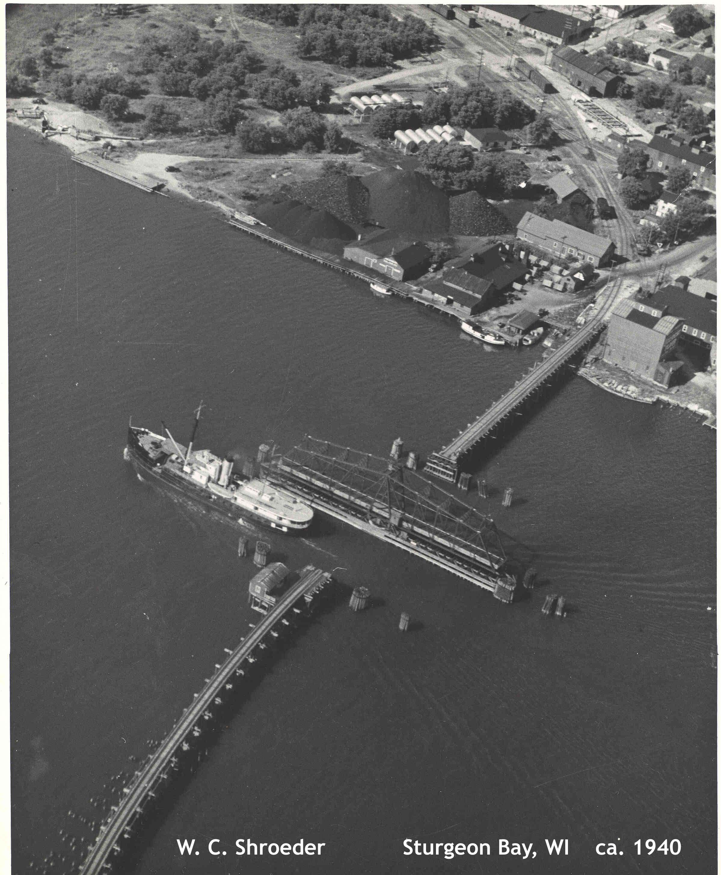
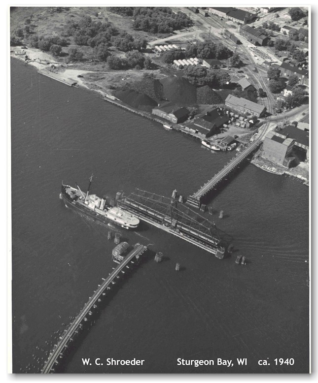
The combination railroad and highway swing bridge is open for ship traffic in this photo from the 1940's.


This view is looking northeast across the Sturgeon Bay Ship Canal. The track curves to the north and extends a few blocks to the Green Bay & Western's depot and engine house in Sturgeon Bay. The bridge served as a combination railroad and highway bridge.

In 1987 the city of Sturgeon Bay dedicated a plaque at the site of the bridge commemorating the history of the Ahnapee & Western's connection to the city.  It read:

"In pioneer times, private boats and commercial ferries were used to cross the waters of Sturgeon Bay.  In 187 the crossing became considerable easier when John D. Leathem and Thomas H. Smith completed a toll bridge consisting of a wooden plank road on a timber pile trestle and a center pivoting truss bridge to allow for boat passage.  Tolls charged   for crossing the bridge included "75�  for threshing outfits," "25� for teams and rider" and 5� per head for foot passengers."

In 1891, the Ahnapee & Western (A&W) Railway received grants totaling $76,000 from the city and County to construct a line to Sturgeon Bay.  A rail crossing was completed in 1894 by attaching tracks to the toll bridge and constructing a new western rail approach.

The City purchased the toll bridge from Leathem and Smith in 1911 and operated it until 1931 when the present Michigan Street bridge was built to accommodate the increased automobile traffic.  The rail portion of the toll bridge was turned over to the A&W which in 1946 reinforced the deteriorating western approach with earth and rock fill, creating the present embankment extending into the bay.

In 1968 the rail line was abandoned, and the old truss bridge and remaining trestle, a serious hazard to navigation, were removed in 1973.  The earthen embankment lay dormant until 1987 when a grant from the Wisconsin Coastal Management Program enabled the city to improve the embankment   for public enjoyment."

This photo was reduced from a high-resolution scan.
To view the original image, click here (463 Kb).


Notice:  This image is owned by Andy Laurent and may not be reproduced without permission.  The original photo was taken by W.C. Schroeder around 1940. Andy obtained the photo from W.C. Schroeder's son Roger Schroeder of the Door County Historical Society.

[ Top of This Page


 The Green Bay Route is maintained by Mark Mathu.
Visit the Guest Book or send comments to mark@mathu.com.
Updated July 11, 2015